

Many years ago, a customer emailed saying that he routinely rows between the same two landmarks on his river. Wouldn’t it be great, he said, if CrewNerd could just start and stop the timer automatically so he could easily compare times from one day to another. After all, CrewNerd knows his location, and he knows the location of the landmarks. Why couldn’t there be a way to tell CrewNerd about the location of the start and finish lines?
A feature is born
Why not, indeed! As a single sculler, I had competed in many head races and was always frustrated by the difficulty of timing my own races. Once you’re approaching the start line, it just isn’t practical to pause to start a timer. The situation at the finish line is only slightly better. Race officials have little patience for rowers who start fiddling with their electronics while other competitors bear down on them.
I loved the idea of solving this problem, so I went to work figuring out how best to accomplish it. Google Earth seemed like the obvious tool for the job. With it, you can explore and annotate any location in a very flexible way. Annotations are exported using Google’s Keyhole Markup Language (KML), which is supported by a wide variety of tools and applications.
With the feature complete, it became possible to identify courses by simply drawing rectangles in Google Earth. When CrewNerd gets two consecutive GPS readings in the “start” rectangle, the timer starts. When you travel through the finish rectangle, the timer stops. Courses are organized in the KML file by placing them under a folder whose name identifies the course, so a single KML file can contain any number of courses.
It works, but…
Note that I said it became possible to do these things. Unfortunately, it still wasn’t easy. In addition to installing Google Earth and learning to use it, there was the challenge of loading the KML file onto your phone. And this part was required even if you had a friend who had done the work of creating the KML file for you. Still, many tech-savvy users began to take advantage of the feature.
As I helped CrewNerd users learn how to do all of this, I thought about sites like Wikiloc. There, hikers can share their favorite trails or download trail maps uploaded by others. I longed for something like that for CrewNerd courses. Wouldn’t it be great if people could just browse a public repository of CrewNerd courses and download the ones they want to use?
Rowsandall to the rescue!
Recently, I discovered that Sander Roosendaal, the founder of the rowing site Rowsandall, had created exactly what was needed! On his training site (by and for rowers!) there is a list of Challenges/Courses. The list includes KML files built in a way that’s compatible with CrewNerd. Rowers on his site can upload their workout data (from any compatible app, not just CrewNerd) and then compare their course times with everyone else on the site.
I had recently worked with Sander to make it easier to export workout data from CrewNerd to Rowsandall, and we began talking about how to enable CrewNerd users to install course data directly from his site. After settling on an approach that made sense, we both went to work on the problem.
Sander added a feature to his site that lets you mark courses you’re interested in by “liking” them, creating a set of “favorites” for each user. He also added a web interface allowing applications like CrewNerd to get a KML file containing all of the liked courses for the signed-in user.
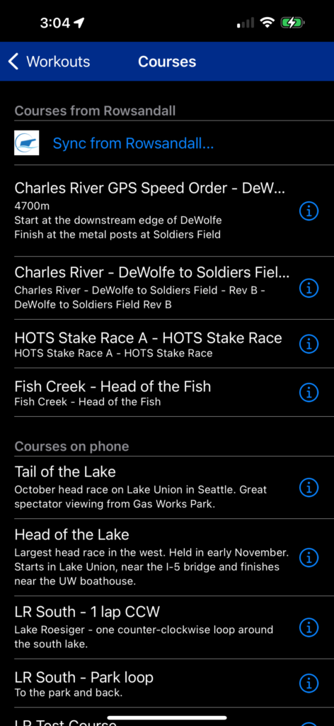
In CrewNerd, I added a new “Sync from Rowsandall” button on the custom courses page in the “workouts” tab. After signing into your Rowsandall account on the CrewNerd settings page, you can simply press the “sync” button to install your favorites courses into the app.
This works in conjunction with the existing feature in CrewNerd, with the courses downloaded from Rowsandall listed above, and in addition to, any courses installed from a local KML file.
But wait, there’s more!
Some time after we introduced custom courses feature, another customer asked about the possibility of supporting “waypoints”. A waypoint is just a place between the start and finish that you must pass through. In a head race, that could be a buoy that you must pass on one side. For this customer, though, they wanted to get help navigating between distant points on a large body of water.
Last year, CrewNerd added support for these as well, and now it can give you information such as: distance to the next waypoint, expected time to reach it, and course corrections along the way.
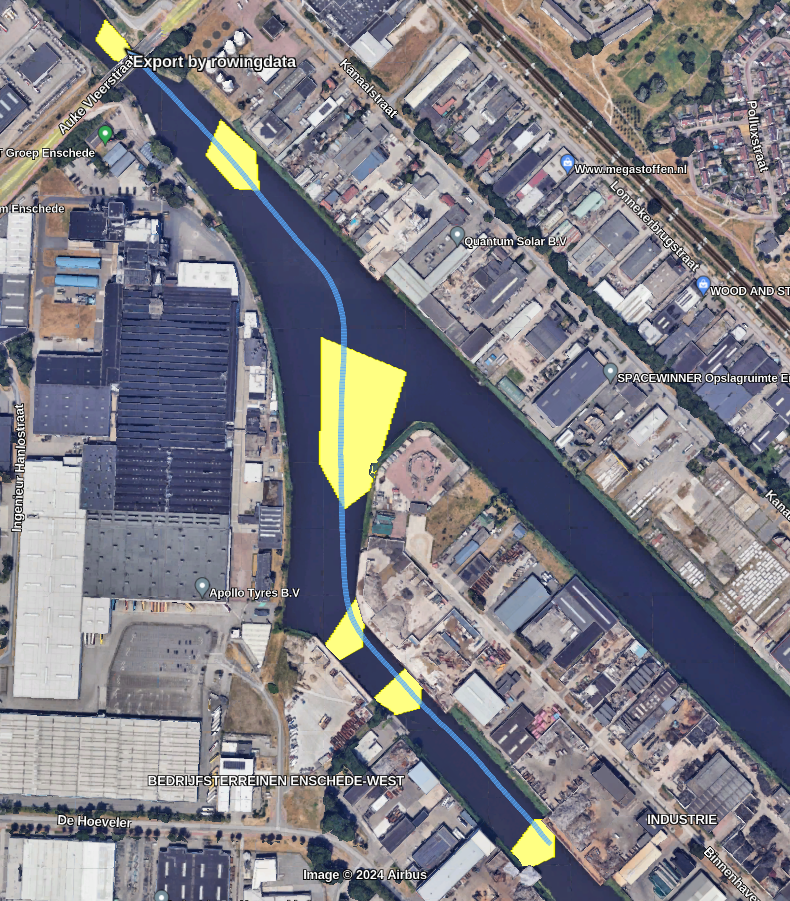
Sander recently designed a course specifically to test this, and as you can see in this recording, he was able to row directly to the target location at the front edge of each waypoint.
Each polygon specifies an area you must row through, but CrewNerd will direct you to the nearest point in the next waypoint. The pointy front edge is there to let CrewNerd help direct you along the best possible path through the course.
One customer described waypoints as their “secret weapon” for head racing. It does take a little additional effort to create them, but the potential benefits are enormous!
Give it a try!
Custom courses have been my favorite under-used feature of CrewNerd for a long time. I hope that many more users will discover their benefits now that they’re so much easier to use. Check out Rowsandall to see what courses are available near you! If you’ve made your own custom courses already, now is the time to upload them to Rowsandall. Then, start posting your workout data for some friendly competition.
As always, we welcome your feedback! Let us know how we make custom courses with Rowsandall even better.
Tony Andrews
April, 2024